D03 JERC Megapit Soils Description
| Print Date: Jul 22 2015 | Country: |
| Description Date: Dec 10 2012 | State: Georgia |
| Describer: Ken Monroe | County: Baker |
| Site ID: S2012GA007002 | MLRA: 133A -- Southern Coastal Plain |
| Site Note: | Soil Survey Area: GA603 -- Baker and Mitchell Counties, Georgia 7-TIF -- Tifton, Georgia |
| Pedon ID: S2012GA007002 | Map Unit: TwB -- Troup sand, 0 to 5 percent slopes |
| Pedon Note: | Quad Name: Hopeful, Georgia |
| Lab Source ID: KSSL | Std Latitude: 31.1960694 |
| Lab Pedon #: 13N0259 | Std Longitude: -84.4664694 |
| User Transect ID: | |
| Soil Name as Described/Sampled: Lucy | |
| Classification: Loamy, kaolinitic, thermic Arenic Kandiudults | Latitude: 31 degrees 11 minutes 45.85 seconds north |
| Soil Name as Correlated: | Longitude: 84 degrees 27 minutes 59.29 seconds west |
| Classification: | Datum: NAD83 |
| Pedon Type: representative pedon for component | UTM Zone: 16 |
| Pedon Purpose: research site | UTM Easting: 741407 meters |
| Taxon Kind: series | UTM Northing: 3454097 meters |
| Associated Soils: Norfork, Orangeburg, Troup, Wagram | |
| Physiographic Division: | Primary Earth Cover: Grass/herbaceous cover |
| Physiographic Province: | Secondary Earth Cover: Intermixed conifers and hardwoods |
| Physiographic Section: | Existing Vegetation: broomsedge bluestem, longleaf pine, turkey oak, wiregrass gentian |
| State Physiographic Area: | Parent Material: loamy marine deposits and/or sandy marine deposits |
| Local Physiographic Area: | Bedrock Kind: |
| Geomorphic Setting: on summit of interfluve of ridge on upland on coastal plain coastal plain | Bedrock Depth: |
| Upslope Shape: convex | Bedrock Hardness: |
| Cross Slope Shape: convex | Bedrock Fracture Interval: |
| Particle Size Control Section: 68 to 118 cm. | Surface Fragments: |
| Description origin: NASIS | Description database: KSSL |
| Diagnostic Features: | ochric epipedon 0 to 68 cm. kandic horizon 68 to 203 cm. argillic horizon 68 to 203 cm. |
| Cont. Site ID: S2012GA007002 | Pedon ID: S2012GA007002 |
| Slope (%) | Elevation (meters) | Aspect (deg) | MAAT (C) | MSAT (C) | MWAT (C) | MAP (mm) | Frost-Free Days | Drainage Class | Slope Length (meters) | Upslope Length (meters) |
| 2.0 | 45.7 | 90 | 27.2 | 11.1 | 1,312 | well |
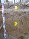
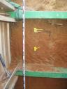
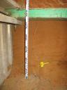
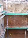
A--0 to 8 centimeters (0.0 to 3.1 inches); grayish brown (10YR 5/2) sand; weak fine granular structure; loose, very friable; very fine roots and fine roots; abrupt smooth boundary. Lab sample # 13N00561
E--8 to 68 centimeters (3.1 to 26.8 inches); yellowish brown (10YR 5/4) oxidized sand; single grain; loose, loose; medium roots and fine roots; clear smooth boundary. Lab sample # 13N00562
Bt1--68 to 105 centimeters (26.8 to 41.3 inches); brown (7.5YR 4/4) oxidized sandy loam; weak medium subangular blocky parts to weak fine subangular blocky structure; slightly hard, friable; medium roots and coarse roots; gradual wavy boundary. Lab sample # 13N00563
Bt2--105 to 185 centimeters (41.3 to 72.8 inches); yellowish red (5YR 4/6) oxidized sandy clay loam; weak medium subangular blocky structure; slightly hard, friable; medium roots; gradual wavy boundary. Lab sample # 13N00564
Bt3--185 to 203 centimeters (72.8 to 79.9 inches); reddish brown (5YR 5/4) oxidized sandy loam; weak fine subangular blocky structure; slightly hard, friable; . Lab sample # 13N00565
 D03_JERC_000-041.JPG