| Print Date: Jul 22 2015 | Country: |
| Description Date: Aug 19 2014 | State: Colorado |
| Describer: Andy Steinert, Clark Harshbarger, Willian Shoup | County: Boulder |
| Site ID: 2014CO013001 | MLRA: 48A -- Southern Rocky Mountains |
| Site Note: This site is the location of the Niwot Ridge NEON (National Ecological Observatory Network) site. All location information was measured at the soil pit. | Soil Survey Area: CO645 -- Arapaho-Roosevelt National Forest Area, Colorado, Parts of Boulder, Clear Creek, Gilpin, Grand, Park and Larimer Counties
4-FTC -- Fort Collins, Colorado |
| Pedon ID: S2014CO013501 | Map Unit: 8776B -- Moran family-Lithic Cryorthents-Rubble land complex, 5 to 40 percent slopes |
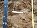
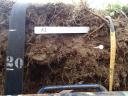
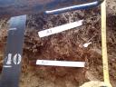
| Pedon Note: At the time of this description there were no series to fit the classification of coarse-loamy, mixed, superactive Typic Haplocryolls. The best fit at this time was to use the 'taxon above family' and call it the Moran Family from the map unit, Moran family-Lithic Cryorthents-Rubble land complex, 5 to 40 percent slopes (MUSYM 8776B). The soil pit was located within this map unit. The Moran family is classified as a loamy-skeletal, mixed, superactive Humic Dystrocryepts in the Arapahoe-Roosevelt National Forest Soil Survey (v3, Dec. 23, 2013). The differences in this pedon are the amount of rock fragments, the paralithic contact, and the mollic epipedon. This pedon has a paralithic contact at 110 centimenters and the rock fragments are less than 35 percent in the particle size control section. The mollic epipedon was very high in organic matter (decompossed) and would be similar to the 'Humic' subgroup for the Dystrocryepts. Please note, that the classification on the OSD for the Moran series has been updated to loamy-skeletal, mixed, superactive Typic Humicryepts. | Quad Name: Ward, Colorado |
| Lab Source ID: KSSL | Std Latitude: 40.0523600 |
| Lab Pedon #: 14N0993 | Std Longitude: -105.5832400 |
| User Transect ID: | |
| Soil Name as Described/Sampled: Moran | |
| Classification: Coarse-loamy, mixed, superactive Typic Haplocryolls | Latitude: 40 degrees 3 minutes 8.50 seconds north |
| Soil Name as Correlated: | Longitude: 105 degrees 34 minutes 59.70 seconds west |
| Classification: | Datum: WGS84 |
| Pedon Type: undefined observation | UTM Zone: 13 |
| Pedon Purpose: research site | UTM Easting: 450252 meters |
| Taxon Kind: taxon above family | UTM Northing: 4433732 meters |
| Associated Soils: Leighcan family, Lithic Cryorthents, Moran family |
| Physiographic Division: Rocky Mountain System | Primary Earth Cover: Grass/herbaceous cover |
| Physiographic Province: Southern Rocky Mountains | Secondary Earth Cover: Tundra rangeland |
| Physiographic Section: | Existing Vegetation: alpine bluegrass, alpine clover, alpine sagebrush, elk sedge, Fern or Fern Ally, fir, moss campion, phlox, Pyrenean sedge, Ross' avens, snow cinquefoil, timber oatgrass |
| State Physiographic Area: | Parent Material: glaciofluvial deposits over residuum weathered from granite, gneiss, schist |
| Local Physiographic Area: Niwot Ridge | Bedrock Kind: granite |
| Geomorphic Setting: on mountainflank, center third of mountain slope on mountain range | Bedrock Depth: 110 centimeters |
| Upslope Shape: convex | Bedrock Hardness: indurated |
| Cross Slope Shape: convex | Bedrock Fracture Interval: |
| Particle Size Control Section: 25 to 100 cm. | Surface Fragments: 3.0 percent nonflat subangular indurated 2- to 75-millimeter granite fragments |
| Description origin: NASIS | Description database: KSSL |
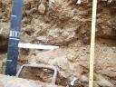
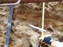
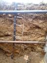
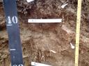
 D13_NIWO_084-113.JPG