D07 ORNL Megapit Soils Description


PEDON DESCRIPTION
Print Date: Jul 22 2015 Country: United States
Description Date: Sep 23 2013 State: Tennessee
Describer: D. Moore, J. Mason, N. Hartgrove, B. Esham County: Anderson
Site ID: S2013TN001001 MLRA: 128 -- Southern Appalachian Ridges and Valleys
Site Note: This is a long term ecological monitoring plot being installed by the National Ecological Observatory Network (NEON). The existing vegetation at the site consists of northern red oak, chestnut oak, red maple, virginia pine, hickory, yellow poplar, sassafras, serviceberry, christmas fern. Soil Survey Area: TN001 -- Anderson County, Tennessee
6-KNO -- Knoxville, Tennessee
Pedon ID: S2013TN001001 Map Unit: FoC -- Fullerton-Pailo complex, 5 to 12 percent slopes
Pedon Note: Quad Name: Bethel Valley, Tennessee
Lab Source ID: KSSL Std Latitude: 35.9645830
Lab Pedon #: 14N0042 Std Longitude: -84.2828060
User Transect ID:  
Soil Name as Described/Sampled: Fullerton  
Classification: Fine, kaolinitic, thermic Typic Paleudults Latitude: 35 degrees 57 minutes 52.50 seconds north
Soil Name as Correlated: Longitude: 84 degrees 16 minutes 58.10 seconds west
Classification: Datum: WGS84
Pedon Type: undefined observation UTM Zone: 16
Pedon Purpose: research site UTM Easting: 745032 meters
Taxon Kind: series UTM Northing: 3983434 meters
Associated Soils:
Physiographic Division: Appalachian Highlands Primary Earth Cover: Tree cover
Physiographic Province: Valley and Ridge Province Secondary Earth Cover: Hardwoods
Physiographic Section: Tennessee section Existing Vegetation:
State Physiographic Area: Parent Material: loamy colluvium derived from cherty limestone over clayey residuum weathered from cherty limestone
Local Physiographic Area: Bedrock Kind:
Geomorphic Setting: on shoulder of crest of river valley on ridge Bedrock Depth:
Upslope Shape: convex Bedrock Hardness:
Cross Slope Shape: concave Bedrock Fracture Interval:
Particle Size Control Section: 19 to 69 cm. Surface Fragments:
Description origin: NASIS Description database: KSSL
Diagnostic Features: ochric epipedon 0 to 19 cm.
argillic horizon 19 to 180 cm.


Cont. Site ID: S2013TN001001 Pedon ID: S2013TN001001


Slope (%) Elevation (meters) Aspect (deg) MAAT (C) MSAT (C) MWAT (C) MAP (mm) Frost-Free Days Drainage Class Slope Length (meters) Upslope Length (meters)
6.0 348.0 18           well    

Oi--0 to 1 centimeters (0.0 to 0.4 inches); moderately decomposed plant material; . Lab sample # 14N00163

A--1 to 10 centimeters (0.4 to 3.9 inches); very dark grayish brown (10YR 3/2) silt loam; weak fine granular structure; very friable; many very fine roots and few medium roots and many fine roots; 10 percent nonflat subrounded strongly cemented 2 to 38-millimeter chert fragments; abrupt smooth boundary. Lab sample # 14N00164

E--10 to 19 centimeters (3.9 to 7.5 inches); brown (10YR 4/3) gravelly silt loam; weak fine subangular blocky structure; very friable; many very fine roots and many medium roots and common fine roots; tubular and dendritic tubular pores; 18 percent nonflat subrounded very strongly cemented 2 to 76-millimeter chert fragments; very strongly acid, pH 4.5, pH indicator solutions; clear smooth boundary. Lab sample # 14N00165

Bt1--19 to 40 centimeters (7.5 to 15.7 inches); yellowish brown (10YR 5/4) gravelly silty clay loam; 28 percent clay; 15 percent medium faint (10YR 5/6) mottles; moderate medium subangular blocky structure; friable; common very fine roots and common fine roots; 30 percent faint clay films; 18 percent nonflat subrounded very strongly cemented 2 to 76-millimeter chert fragments; very strongly acid, pH 4.5, pH indicator solutions; clear smooth boundary. Lab sample # 14N00166

2Bt2--40 to 65 centimeters (15.7 to 25.6 inches); yellowish red (5YR 5/6) silty clay loam; 37 percent clay; 25 percent coarse distinct (7.5YR 6/6) mottles; moderate medium subangular blocky structure; friable; few fine roots; 60 percent distinct clay films; 5 percent nonflat subrounded very strongly cemented 2 to 76-millimeter chert fragments; very strongly acid, pH 4.5, pH indicator solutions; clear smooth boundary. Lab sample # 14N00167

2Bt3--65 to 147 centimeters (25.6 to 57.9 inches); red (2.5YR 4/6) extremely cobbly clay; 53 percent clay; strong medium angular blocky structure; firm; few very fine roots and few fine roots; 60 percent distinct clay films; 15 percent nonflat subangular very strongly cemented 2 to 76-millimeter chert fragments and 47 percent nonflat subrounded very strongly cemented 76 to 250-millimeter chert fragments; very strongly acid, pH 4.5, pH indicator solutions; gradual smooth boundary. Lab sample # 14N00168

2Bt4--147 to 180 centimeters (57.9 to 70.9 inches); red (2.5YR 5/6) extremely gravelly clay; 55 percent clay; 15 percent medium distinct (5YR 5/8) and 15 percent medium prominent (7.5YR 6/8) mottles; strong medium angular blocky structure; firm; 60 percent distinct clay films; 10 percent nonflat subrounded very strongly cemented 76 to 250-millimeter chert fragments and 55 percent nonflat subangular very strongly cemented 2 to 76-millimeter chert fragments; very strongly acid, pH 4.5, pH indicator solutions. Lab sample # 14N00169


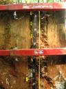
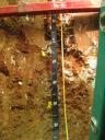
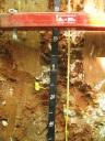
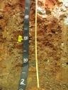
D07_ORNL_Profile_011-128.JPG

D07_ORNL_Profile_073-193.JPG

D07_ORNL_055-153.JPG

D07_ORNL_124-200.JPG

D07_ORNL_Profile_000-200.JPG

D07_ORNL_000-003.JPG

D07_ORNL_009-045.JPG

D07_ORNL_027-067.JPG