D05 STEI Megapit Soils Description
| Print Date: Feb 18 2016 | Country: United States |
| Description Date: Jun 17 2015 | State: Wisconsin |
| Describer: Ryan Bevernitz, Phil Meyer, Scott Eversoll | County: Lincoln |
| Site ID: 2015WI069001 | MLRA: 94D -- Northern Highland Sandy Drift |
| Site Note: | Soil Survey Area: 10-RHI -- Rhinelander, Wisconsin |
| Pedon ID: S2015WI069001 | Map Unit: MxB -- Moodig sandy loam, 0 to 4 percent slopes |
| Pedon Note: The soil gets coarser as the depth increases. | Quad Name: |
| Lab Source ID: KSSL | Std Latitude: 45.5074944 |
| Lab Pedon #: 15N0685 | Std Longitude: -89.5888861 |
| User Transect ID: | |
| Soil Name as Described/Sampled: | |
| Classification: | Latitude: 45 degrees 30 minutes 26.98 seconds north |
| Soil Name as Correlated: Pesabic | Longitude: 89 degrees 35 minutes 19.99 seconds west |
| Classification: Coarse-loamy, mixed, superactive, frigid Alfic Epiaquods | Datum: NAD83 |
| Pedon Type: undefined observation | UTM Zone: |
| Pedon Purpose: ecological site data | UTM Easting: |
| Taxon Kind: series | UTM Northing: |
| Associated Soils: | |
| Physiographic Division: | Primary Earth Cover: Tree cover |
| Physiographic Province: | Secondary Earth Cover: Hardwoods |
| Physiographic Section: | Existing Vegetation: balsam fir, baneberry, black raspberry, bunchberry dogwood, fly honeysuckle, goldenrod, hawkweed, ironwood, quaking aspen, red maple, sedge, shieldfern, starflower, white ash |
| State Physiographic Area: | Parent Material: sandy and loamy till |
| Local Physiographic Area: | Bedrock Kind: |
| Geomorphic Setting: on shoulder of moraine on pitted outwash plain | Bedrock Depth: |
| Upslope Shape: | Bedrock Hardness: |
| Cross Slope Shape: | Bedrock Fracture Interval: |
| Particle Size Control Section: | Surface Fragments: |
| Description origin: NASIS | Description database: KSSL |
| Diagnostic Features: | ochric epipedon 0 to 14 cm. spodic horizon 14 to 36 cm. glossic horizon 36 to 61 cm. argillic horizon 61 to 109 cm. densic materials 148 to 200 cm. |
| Top Depth (cm) | Bottom Depth (cm) | Restriction Kind | Restriction Hardness |
| 148 | 200 | densic material |
| Cont. Site ID: 2015WI069001 | Pedon ID: S2015WI069001 |
| Slope (%) | Elevation (meters) | Aspect (deg) | MAAT (C) | MSAT (C) | MWAT (C) | MAP (mm) | Frost-Free Days | Drainage Class | Slope Length (meters) | Upslope Length (meters) |
| 3.0 | 473.5 | 280 | somewhat poorly |
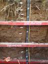
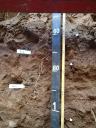
A--0 to 14 centimeters (0.0 to 5.5 inches); light brownish gray (10YR 6/2) silt loam; moderate medium granular structure; very friable; very fine roots and medium roots and fine roots and coarse roots; 5 percent nonflat subrounded indurated 2 to 75-millimeter mixed rock fragments; moderately acid, pH 5.8, Hellige-Truog; clear wavy boundary. Lab sample # 15N03525. 10 percent uncoated sand grains
Bs1--14 to 28 centimeters (5.5 to 11.0 inches); dark brown (7.5YR 3/4) fine sandy loam; moderate medium subangular blocky structure; friable; very fine roots and medium roots and fine roots and coarse roots; 2 percent nonflat subrounded indurated 250 to 600-millimeter mixed rock fragments and 9 percent nonflat subrounded indurated 2 to 75-millimeter mixed rock fragments; strongly acid, pH 5.4, Hellige-Truog; clear smooth boundary. Lab sample # 15N03526
Bs2--28 to 36 centimeters (11.0 to 14.2 inches); brown (7.5YR 4/3) sandy loam; moderate medium subangular blocky structure; friable; very fine roots and medium roots and fine roots and coarse roots; 2 percent nonflat subrounded indurated 250 to 600-millimeter mixed rock fragments and 9 percent nonflat subrounded indurated 2 to 75-millimeter mixed rock fragments; strongly acid, pH 5.5, Hellige-Truog; clear smooth boundary. Lab sample # 15N03527
E/B--36 to 61 centimeters (14.2 to 24.0 inches); 55 percent brown (7.5YR 5/3) and 45 percent brown (7.5YR 4/3) gravelly sandy loam; strong coarse subangular blocky structure; friable; very fine roots and medium roots and fine roots; 10 percent medium distinct 7.5YR 4/6), moist, masses of oxidized iron and 10 percent fine distinct 7.5YR 5/2), moist, clay depletions; 5 percent nonflat subrounded indurated 250 to 600-millimeter mixed rock fragments and 10 percent nonflat subrounded indurated 2 to 75-millimeter mixed rock fragments; strongly acid, pH 5.3, Hellige-Truog; clear wavy boundary. Lab sample # 15N03528
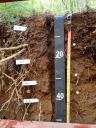
Bt1--61 to 78 centimeters (24.0 to 30.7 inches); dark brown (7.5YR 3/4) gravelly sandy loam; moderate coarse subangular blocky structure; friable; very fine roots and medium roots and fine roots; 10 percent faint 7.5YR 3/3), moist, clay films on all faces of peds; 25 percent coarse prominent 5YR 5/8), moist, masses of oxidized iron and 25 percent medium distinct 7.5YR 5/2), moist, clay depletions; 25 percent nonflat subrounded indurated 2 to 75-millimeter mixed rock fragments; strongly acid, pH 5.3, Hellige-Truog; gradual wavy boundary. Lab sample # 15N03529
Bt2--78 to 109 centimeters (30.7 to 42.9 inches); brown (7.5YR 4/4) gravelly sandy loam; weak medium subangular blocky structure; friable; very fine roots and medium roots and fine roots; 10 percent faint 7.5YR 4/3), moist, clay films on all faces of peds; 1 percent medium prominent 10Y 6/), moist, clay depletions and 25 percent coarse prominent 5YR 4/6), moist, and 7.5YR 5/8), moist, masses of oxidized iron and 25 percent medium prominent 2.5Y 6/2), moist, clay depletions; 5 percent nonflat subrounded indurated 75 to 250-millimeter mixed rock fragments and 15 percent nonflat subrounded indurated 2 to 75-millimeter mixed rock fragments; moderately acid, pH 5.7, Hellige-Truog; gradual wavy boundary. Lab sample # 15N03530. pockets of silt loam with redox throught.
BC--109 to 148 centimeters (42.9 to 58.3 inches); brown (7.5YR 4/4) very gravelly sandy loam; weak medium subangular blocky structure; friable; very fine roots and medium roots and fine roots; 10 percent medium prominent 5YR 5/3), moist, clay depletions and 10 percent medium prominent 5YR 4/6), moist, masses of oxidized iron; 15 percent nonflat subrounded indurated 75 to 250-millimeter mixed rock fragments and 20 percent nonflat subrounded indurated 2 to 75-millimeter mixed rock fragments; moderately acid, pH 5.9, Hellige-Truog; clear wavy boundary. Lab sample # 15N03531
Cd--148 to 200 centimeters (58.3 to 78.7 inches); reddish brown (5YR 4/3) gravelly sandy loam; structureless massive; firm; 10 percent coarse prominent 10YR 5/2), moist, clay depletions and 25 percent very coarse prominent 5YR 4/6), moist, masses of oxidized iron; 2 percent nonflat subrounded indurated 250 to 600-millimeter mixed rock fragments and 5 percent nonflat subrounded indurated 75 to 250-millimeter mixed rock fragments and 15 percent nonflat subrounded indurated 2 to 75-millimeter mixed rock fragments; slightly acid, pH 6.2, Hellige-Truog. Lab sample # 15N03532
 D05_STEI_Profile_000-180.JPG