| Print Date: Jul 22 2015 | Country: |
| Description Date: Apr 8 2013 | State: Colorado |
| Describer: Andy Steinert | County: Logan |
| Site ID: S2013CO075001 | MLRA: 72 -- Central High Tableland |
| Site Note: Sterling NEON (National Ecological Observatory Network) pit | Soil Survey Area: CO075 -- Logan County, Colorado
5-FTM -- Fort Morgan, Colorado |
| Pedon ID: S2013CO075001 | Map Unit: 126 -- Weld loam, 1 to 3 percent slopes |
| Pedon Note: | Quad Name: Buffalo Springs Ranch NE, Colorado |
| Lab Source ID: SSL | Std Latitude: 40.4598333 |
| Lab Pedon #: 13N39573 | Std Longitude: -103.0300833 |
| User Transect ID: | |
| Soil Name as Described/Sampled: Goshen | |
| Classification: Fine-silty, mixed, superactive, mesic Pachic Argiustolls | Latitude: 40 degrees 27 minutes 35.40 seconds north |
| Soil Name as Correlated: | Longitude: 103 degrees 1 minutes 48.30 seconds west |
| Classification: | Datum: WGS84 |
| Pedon Type: correlates to named soil | UTM Zone: 13 |
| Pedon Purpose: research site | UTM Easting: 667024 meters |
| Taxon Kind: series | UTM Northing: 4480661 meters |
| Associated Soils: |
| Physiographic Division: Interior Plains | Primary Earth Cover: Crop cover |
| Physiographic Province: Great Plains Province | Secondary Earth Cover: Close-grown crop |
| Physiographic Section: Colorado Piedmont | Existing Vegetation: |
| State Physiographic Area: | Parent Material: local alluvium |
| Local Physiographic Area: | Bedrock Kind: |
| Geomorphic Setting: drainageway on upland | Bedrock Depth: |
| Upslope Shape: linear | Bedrock Hardness: |
| Cross Slope Shape: concave | Bedrock Fracture Interval: |
| Particle Size Control Section: 28 to 78 cm. | Surface Fragments: |
| Description origin: Pedon PC 5.1 | Description database: KSSL |
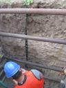
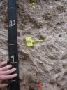
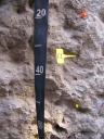
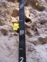
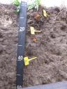
 D10_STER_Profile_000-200.JPG